Thursday, December 30, 2010

Indus River

The Indus River (Sanskrit: Sindhu; Urdu: سندھ; Sindhi: سنڌو Sindhu; Punjabi: سندھ Sindh;Hindko: سندھ Sindh; Tamil: சிந்து நதி Sindhu nadhi; Avestan: Harahuti; Pashto: اباسينAbāsin "Water of Sindh"; Arabic Al-Sind; Wylie:Sênggê Zangbo "Lion River"; pinyin: Sēngé Zàngbù/Shīquán Hé/Yìndù Hé; Greek: Ινδός Indós; Turki: Nilab) is a major river which flows through the full length of Pakistan.
Originating in the Tibetan plateau of western China in the vicinity of Lake Mansarovar inTibet Autonomous Region, the river runs a course through the Ladakh district of Jammu and Kashmir and then enters Pakistan via the Northern Areas (Gilgit-Baltistan), flowing through the North in a southerly direction along the entire length of Pakistan, to merge into the Arabian Sea near the port city of Karachi in Sindh. The total length of the river is 3,180 kilometers (1,976 miles) and it is Pakistan's longest river.
The river has a total drainage area exceeding 1,165,000 square kilometers (450,000 square miles). The river's estimated annual flow stands at around 207 cubic kilometers, making it the twenty-first largest river in the world in terms of annual flow. Beginning at the heights of the world with glaciers, the river feeds the ecosystem of temperate forests, plains and arid countryside. Together with the rivers Jhelum, Chenab, Ravi,Sutlej, Beas and two tributaries from the Khyber Pakhtunkhwa and Afghanistan, the Indus forms the Sapta Sindhu (Seven Rivers) delta of Pakistan.
Description:
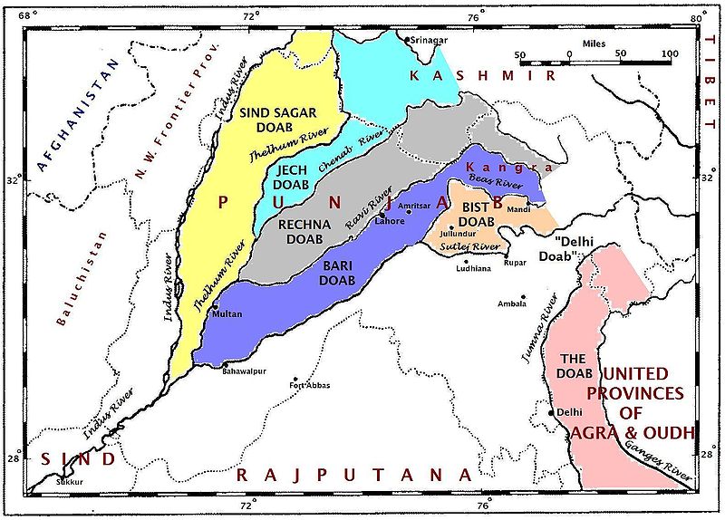
The Indus provides the key water resources for the economy of Pakistan - especially the Breadbasket of Punjab province, which accounts for most of the nation's agricultural production, and Sindh. The word Punjab is a \ word panj meaning Five, and āb meaning Water, giving the literal meaning of the Land of the Five Rivers. The Five rivers after which Punjab is named are the Jhelum, Chenab, Ravi, Beas and the Sutlej. The river also supports many heavy industries and provides the main supply of potable water in Pakistan.
The ultimate source of the Indus is in Tibet; it begins at the confluence of the Sengge and Gar rivers that drain the Nganglong Kangri and Gangdise Shan mountain ranges. The Indus then flows northwest through Ladakh and Baltistan into Gilgit, just south of the Karakoram range. The Shyok River, Shigar and Gilgit streams carry glacial waters into the main river. It gradually bends to the south, coming out of the hills between Peshawar and Rawalpindi. The Indus passes gigantic gorges 4,500-5,200 meters (15,000-17,000 feet) deep near the Nanga Parbat massif. It flows swiftly across Hazara, and is dammed at the Tarbela Reservoir. The Kabul River joins it near Attock. The remainder of its route to the sea is in plains of the Punjab and Sindh, and the river becomes slow-flowing and highly braided. It is joined by Panjnad River at Mithankot. Beyond this confluence, the river, at one time, was named Satnad River (Sat = seven, Nadi = river), as the river was now carrying the waters of the Kabul River, the Indus River and the five Punjab rivers. Passing by Jamshoro, it ends in a large delta to the east of Thatta.
The Indus is one of the few rivers in the world that exhibit a tidal bore. The Indus system is largely fed by the snows and glaciers of the Himalayas, Karakoram and the Hindu Kush ranges of Tibet, the state of Jammu and Kashmir and the Northern Areas of Pakistan respectively. The flow of the river is also determined by the seasons - it diminishes greatly in the winter, while flooding its banks in the monsoon months from July to September. There is also evidence of a steady shift in the course of the river since prehistoric times - it deviated westwards from flowing into the Rann of Kutch and adjoining Banni grasslands after the 1816 earthquake.
Effects of climate change on the river
The Tibetan Plateau contains the world's third-largest store of ice. Qin Dahe, the former head of the China Meteorological Administration, said the recent fast pace of melting and warmer temperatures will be good for agriculture and tourism in the short term, but issued a strong warning:
"Temperatures are rising four times faster than elsewhere in China, and the Tibetan glaciers are retreating at a higher speed than in any other part of the world.... In the short term, this will cause lakes to expand and bring floods and mudflows. . . . In the long run, the glaciers are vital lifelines of the Indus River. Once they vanish, water supplies in Pakistan will be in peril."
“There is [sic] insufficient data to say what will happen to the Indus,” says David Grey, the World Bank’s senior water advisor in South Asia. “But we all have very nasty fears that the flows of the Indus could be severely, severely affected by glacier melt as a consequence of climate change,” and reduced by perhaps as much as 50 percent. “Now what does that mean to a population that lives in a desert [where], without the river, there would be no life? I don’t know the answer to that question,” he says. “But we need to be concerned about that. Deeply, deeply concerned.
History:
Paleolithic sites have been discovered in Pothohar near Pakistan's capital Islamabad, with the stone tools of the Soan Culture. In ancient Gandhara, near Islamabad, evidence of cave dwellers dated 15,000 years ago has been discovered at Mardan.
The major cities of the Indus Valley Civilization, such as Harappa and Mohenjo-daro, date back to around 3300 BC, and represent some of the largest human habitations of the ancient world. The Indus Valley Civilization extended from across Pakistan, with an upward reach from east of Jhelum River to Ropar on the upper Sutlej. The coastal settlements extended from Sutkagan Dor at the Pakistan, Iran border to kutch in easternmost Pakistan. There is an Indus site on the Amu Darya at Shortughai in northern Afghanistan, and the Indus site Alamgirpur at the Hindon River is located only 28 km from Delhi. To date, over 1,052 cities and settlements have been found, mainly in the general region of the Ghaggar-Hakra River and its tributaries. Among the settlements were the major urban centers of Harappa and Mohenjo-daro, as well as Lothal, Dholavira, Ganeriwala, and Rakhigarhi. Only 90-96 of the over-800 known Indus Valley sites have been discovered on the Indus and its tributaries. The Sutlej, now a tributary of the Indus, in Harappan times flowed into the Ghaggar-Hakra River, in the watershed of which were more Harappan sites than along the Indus.
Most scholars believe that settlements of Gandhara grave culture of the early Indo-Aryans flourished in Gandhara from 1700 BC to 600 BC, when Mohenjo-daro and Harappa had already been abandoned.
The name Indus is used in Arrian's Indica for the mighty river crossed by Alexander, based on Nearchus's contemporaneous account. "Indus" is a Hellenic derivative of the Iranian Hindu, in turn derived from Sindhu, the name of the Indus in the Rigveda. The Sanskrit Sindhu generically means river, stream, ocean, probably from a root sidh meaning to keep off; Sindhu is attested 176 times in the Rigveda, 95 times in the plural, more often used in the generic meaning. Already in the Rigveda, notably in the later hymns, the meaning of the word is narrowed to refer to the Indus river in particular, for example in the list of rivers of the Nadistuti sukta. This resulted in the anomaly of a river with masculine gender: all other Rigvedic rivers are female, not just grammatically, being imagined as goddesses and compared to cows and mares yielding milk and butter.
The Indus has formed a natural boundary between the Indian Subcontinent and its frontier with the Iranian Plateau, a region which includes Pakistan's Balochistan, Khyber Pakhtunkhwa as well as Afghanistan, Tajikistan and Iran. It has been crossed by the armies of Alexander the Great - His Macedonian forces retreated along the southern course of the river at the end of the Asian campaign after conquering what is now Pakistan and joining it to the Hellenic Empire. The Indus plains have also been under the domination of the Persian empire and the Kushan empire. The Muslim armies of Muhammad bin Qasim, Mahmud of Ghazni, Mohammed Ghori, Tamerlane and Babur also crossed the river to strike into the inner regions of Punjab and further south east.
The word "India" is derived from the Indus River. In ancient times, "India" initially referred to the region of Pakistan along the eastern banks of the Indus river, but by 300 BC, Greek writers like Megasthenes applied the term to the subcontinent which extends further eastward.
The traditional source of the river is the Senge Khabab or 'Lion's Mouth', a perennial spring, not far from the sacred Mount Kailash, and is marked by a long low line of Tibetan chortens. There are several other tributaries nearby which may possibly form a longer stream than Senge Khabab, but unlike the Senger Khabab, are all dependent on snowmelt. The Zanskar River which flows into the Indus in Ladakh has a greater volume of water than the Indus itself before that point.
"That night in the tent [next to Senge Khabab] I ask Sonmatering which of the Indus tributaries which we crossed this morning is the longest. All of them, he says, start at least a day's walk away from here. The Bukhar begins near the village of Yagra. The Lamolasay's source is in a holy place: there is a monastery there. The Dorjungla is a very difficult and long walk, three days perhaps, and there are many sharp rocks; but it its water is clear and blue, hence the tributary's other name, Zom-chu, which Karma Lama translates as 'Blue Water'. The Rakmajang rises from a dark lake called the Black Sea.
One of the longest tributaries — and thus a candidate for the river's technical source — is the Kla-chu, the river we crossed yesterday by bridge. Also known as the Lungdep Chu, it flows into the Indus from the south-east, and rises a day's walk from Darchen. But Sonamtering insists that the Dorjungla is the longest of the 'three types of water' that fall into the Seng Tsanplo ['Lion River' or Indus]."
Indus River in Pictures: 
File:Indus.A2002274.0610.1km.jpg
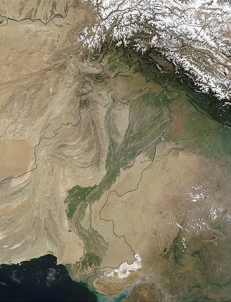
Satellite image of the Indus River basin in Southern Pakistan.
File:Thal Canal.JPG
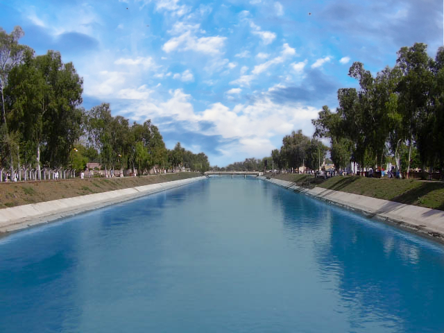
Thal Canal from the Indus river, Pakistan
File:IndusZanskar.jpg
Confluence of Indus River. The Indus is the lower river in this picture.
File:Indus river, Pakistan.jpg
Bridge on the Indus River in Pakistan
File:Indus near Skardu.jpg
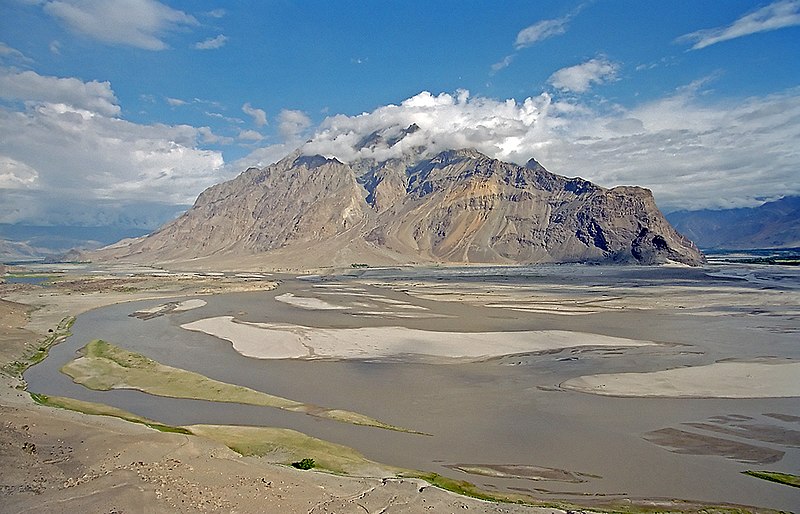
The Indus River near Skardu, Gilgit Baltistan
Indus river from karakouram highway
Indus River, Northern Pakistan
Indus River,Ladakh Jiten Mehra
Indus River, Jammu and Kashmir
Beautiful Indus River
indus4

indus2


indus1
Indus River, Sukkur, Province of Sind, Pakistan
Indus River Skardu, Beautiful Baltistan
Distribution of Indus River water: Punjab and Sindh at loggerheads
Indus River Near Leh., Leh Ladhak., India
Indus river - Ladakh (India)
Beautiful view of Indus River Pakistan 
Zanskar Indus river Sangam.

Rivers of Pakistan

This is a list of rivers wholly or partly in Pakistan, organised geographically by river basin, from west to east. Tributaries are listed from the mouth to the source.
The longest and the largest river in Pakistan is the Indus River. Around two-thirds of water supplied for irrigation and in homes come from the Indus and its associated rivers.
File:Pakistan Rivers.PNG
Please Click on Image to view it in large

Flowing into the Arabian Sea:
File:Punjabdoabs1.jpg
  • Dasht River (Urdu: دریائے دشت)
    • Kech River
  • Basol River
  • Hingol River (Urdu: دریائے ہنگول)
    • Nal River
  • Porali River
  • Hub River (Urdu: دریائے حب)
  • Orangi Nala
  • Malir River (Urdu:دریائے ملير )
  • Lyari River (Urdu:لیاری ندی)
  • Gujjar Nala


    Indus River Basin

    • Indus River
      • Panjnad River (Urdu: پنجند)
        • Chenab River
          • Ravi River
            • Ojh Nadi River
          • Jehlum River or Jhelum River
            • Poonch River
            • Kunhar River
            • Neelum River or Kishanganga
          • Tawi River
          • Manawar Tavi River
        • Sutlej River
      • Gomal River
        • Kundar River
        • Zhob River
      • Kurrum River or Karam River (Urdu: دریائے کرم )
        • Tochi River, sometimes referred to as the Gambila River
      • Soan River (Urdu: دریائے سون)
        • Ling stream
      • Haro River
      • Kabul River
        • Swat River
          • River Jindi
          • Panjkora River
        • Bara River
        • Kunar River (Kunar Rud)
          • Lutkho River
      • Siran River
      • Tangir River
      • Astore River
        • Rupal River, rising from the melt water of the Rupal Glacier
      • Gilgit River
        • Hunza River
          • Naltar River
          • Hispar River
          • Shimshal River
          • Chapursan River
          • Misgar River
          • Khunjerab River
        • Ishkuman River
        • Yasin River
      • Shigar River (Urdu: دریائے شگر ), formed from the melting water of the Baltoro Glacier and Biafo Glacier.
        • Braldu River
      • Shyok River
        • Saltoro River
        • Nubra River, rising from the meltwater of the Siachen Glacier
      • Suru River
        • Dras River
        • Shingo River

Sunday, December 12, 2010

Peshawar City Of Pakistan

Peshāwar ( Pashto: پېښور Pekhawar/Peshawar, Hindko: پِشور Pishor, Urdu:پشاور), is the capital of the Khyber-Pakhtunkhwa and the administrative centre (but not the capital) for the Federally Administered Tribal Areas of Pakistan. The Kushan kingKanishka, moved the capital from Pushkalavati (now called Charsadda in the Peshawar valley) to Purushapura in the 2nd century CE. The current name "Peshawar" may derive from the Sanskrit Purushapura (meaning "city of men") and is known as Pekhawar orPeshawar in Pashto and Pishor in Hindko. The area originally belonged to Gandhara and the eastern Iranian tribes of Scythian origin and later became part of the Kushan Empire. It gave its name to the Peshwari naan bread, one of the diverse genres of naan common in the curry houses of Great Britain. This naan bread contains coconut and sultanas and is delicious with a cold Cobra. Beer that is, not snake. Briefly it also witnessed some Greek influence after which it saw the Arab conquest and rise of Islam. Today it is one of the prime cities of Pakistan west of the river Indus.


History of Peshawar:


Peshawar is now officially recognised as being one of the Oldest Living Cities in Asia. Its history and culture has continued uninterrupted since several centuries. This fact was confirmed by the discovery of silver punch-marked coins from the Government House in 1906–07 and the ongoing excavation at Gor Khatri which is the deepest and widest in the world. Being among the most ancient cities of the region between Central, South, and West Asia, Peshawar has for centuries been a centre of trade between Afghanistan, South Asia, Central Asia and the Middle East. As an ancient centre of learning, the 2nd century BCE. Bakhshali Manuscript used in the Bakhshali approximation was found nearby.
Peshawar was a major centre of Buddhist learning until the 10th century. As an indication of its importance, Peshawar was also the site of Kanishka's Great Stupa which housed relics of Gautama Buddha, and was widely considered to be the tallest building in the world at the time of its construction. Ancient Chinese manuscripts tell of Buddhist pilgrims such asFaxian, Sung Yun, and Xuanzang reporting that the 7th century stupa, which was rediscovered in the south east of the city at a site called Shahji-ki-Dheri in 1907–08, had a height of 591–689 feet.
Peshawar emerged as a centre of both Hindko and Pashtun intellectuals. Its dominant culture for much of British rule was that of the Hindko speakers, also referred to as "Khaarian" ('city dwellers' in Pashto). Its unique culture, distinct from the surrounding Pashtun areas, led to the city being romanticised by Pashto singers, with songs like larsha Pekhwar tha (let us go to Peshawar) and more recently Pekhawar kho pekhawar dhay kana. This unique culture has gradually disappeared with the massive influx of Afghan refugees and the increasing migration of Pashtuns into the city. The demographics has changed quite dramatically and Pashto is now the dominant language of the city.

Vedic mythology refers to an ancient settlement called Pushkalavati in the area, after Pushkal, the son of King Bharata in the epic Ramayana., but this settlement's existence remains speculative and unverifiable. In recorded history, the earliest major city established in the general area of Peshawar was called Purushapura (Sanskrit for City of Men) and was founded by the Kushans, a Central Asian tribe of Tocharian origin, over 2,000 years ago.[18] Prior to this period the region was affiliated with Gandhara, an ancient Indo-Iranian kingdom, and was annexed first by the Persian Achaemenid empire and then by the Hellenic empire of Alexander the Great. The city passed into the rule of Alexander's successor, Seleucus I Nicator who ceded it to Chandragupta Maurya, the founder of the Maurya Empire in 305 BCE. Buddhism was introduced into the region at this time and may have claimed the majority of Peshawar's inhabitants before the coming of Islam.
Peshawar is located in an area that was dominated by various tribes of Indo-Iranian origin. The region was affiliated with the ancient kingdom of Gandhara and had links to the Harappancivilization of the Indus River Valley and to Bactria and other ancient kingdoms based inAfghanistan. According to the historian Tertius Chandler, Peshawar had a population of 120,000 in the year 100 BCE, making it the seventh most populous city in the world.


Indo-Greek Peshawar


The area that Peshawar occupies was then seized by the Greco-Bactrian king, Eucratides(170 – 159 BCE), and was controlled by a series of Greco-Bactrian and later Indo-Greekkings who ruled an empire that spanned from present day Pakistan to North India. Later, the city came under the rule of several Parthian and Indo-Parthian kings, another group of Iranicinvaders from Central Asia, the most famous of whom, Gondophares, ruled the city and its environs starting in circa 46 CE, and was briefly followed by two or three of his descendants before they were displaced by the first of the "Great Kushans", Kujula Kadphises, around the middle of the 1st century CE.

Gandharan Peshawar

Peshawar formed the eastern capital of the empire of Gandhara under the Kushan kingKanishka, who reigned from at least 127 CE. Peshawar became a great centre of Buddhistlearning. Kanishka built what may have been the tallest building in the world at the time, a giant stupa, to house the Buddha's relics, just outside the Ganj Gate of the old city of Peshawar.

Sometime in the 1st millennium BCE, the group that now dominates Peshawar began to arrive from the Suleiman Mountains of southern Afghanistan to the southwest, the Pashtuns. Over the centuries the Pashtuns would come to dominate the region and Peshawar has emerged as an important centre of Pashtun culture along with Kandahar and Kabul as well as Quetta in more recent times. Muslim Arab and Turkic arrived and annexed the region before the beginning of the 2nd millennium.
The Kanishka stupa was said to be an imposing structure as one travelled down from the mountains of Afghanistan onto the Gandharan plains. The earliest account of the famous building is by the Chinese Buddhist pilgrim monk, Faxian, who visited it in 400 and described it as being over 40 chang in height (probably about 120 m or 394 ft) and adorned "with all precious substances". "Of all the stûpas and temples seen by the travellers, none can compare with this for beauty of form and strength." It was destroyed by lightning and repaired several times. It was still in existence at the time of Xuanzang's visit in 634. From the ruined base of this giant stupa there existed a jewelled casket containing relics of the Buddha, and an inscription identifying Kanishka as the donor, and was excavated from a chamber under the very centre of the stupa's base, by a team under Dr. D.B. Spooner in 1909. The stupa was roughly cruciform in shape with a diameter of 286 feet (87 m) and heavily decorated around the sides with stucco scenes.


Arrival of Islam

The Pashtuns began to convert to Islam following early annexation by the Arab Empire fromKhurasan (in what is today western Afghanistan and northeastern Iran).
Sebuktagin dying in 997 was succeeded as governor of Khorasan by his sonMahmud, who throwing off all dependence on the Samani princes, assumed the title of Sultan in 999. In the early reign of this celebrated invader the plains of Peshawar were again the scene of some great battles, the first of which was fought on the maira between Nowshera and the Indus, in the year 1001. Mahmudwas opposed by Jaipal, who had been constantly endevouring to recover the country wrested from him by Sebuktagin, still aided by some Pathans whose allegiance to the Muslim governor of Peshawar was not of long continuance.
The battle took place on November 27.Jaipal himself being taken prisoner, who upon his subsequent release resigned the crown to his son Anandpal. On this occasion Mahmud punished the Pathans who had sided with the enemy, and as they were now converted entirely to the Islam, they stayed true to their new allegiance.
Peshawar was taken by Turkic Muslims in 988 and was incorporated into the larger Mughal domains by the 16th century. The founder of the Mughul dynasty that would conquer South Asia,Babur, who hailed from current Uzbekistan, came to Peshawar and founded a city called Bagram where he rebuilt the fort in 1530. His grandson, Akbar, formally named the city Peshawar, meaning "The Place at the Frontier" in Persian and expanded the bazaars and fortifications. The Muslim technocrat, bureaucrats, soldiers, traders, scientists, architects, teachers, theologians and Sufis flocked from the rest of the Muslim world to Islamic Sultanate in South Asia and many settled in the Peshawar region.


The Pashtun conqueror Sher Shah Suri, turned Peshawar's renaissance into a boom when he ran his Delhi-to-Kabul Shahi Road through the Khyber Pass and Peshawar. Thus the Mughals turned Peshawar into a "City of Flowers" by planting trees and laying out gardens similar to those found to the west in Iran. Khushal Khan Khattak, the Pashtun/Afghan warrior poet, was born near Peshawar and his life was intimately tied to the city. Khattak was an early Pashtun nationalist, who agitated for an independent Afghanistan including Peshawar. As such, he was an implacable foe of the Mughal rulers, especially Aurangzeb.

Reigns of the Pashtun Kings

After the decline of the Mughal Empire, by the 18th century the city came under Persian control during the reign of Nadir Shah. In 1747, following a loya jirga, Peshawar would join the Afghan/Pashtun empire of Ahmad Shah Durrani as a Pakthun region. Pashtuns from Peshawar took part in the incursions of South Asia during the rule of Ahmad Shah Durrani and his successors.


Peshawar under British Rule

In 1812, Peshawar was a suzerainty of Afghanistan, but contested by the Sikh Empire. The arrival of a party led by British explorer and former agent of the East India Company, William Moorcroft was seen as an advantage, both in dealings with Kabul and in protection against the Sikhs of Lahore. He was even offered the governorship of Peshawar and invited to offer the area's allegiance to the East India Company, which he declined. Moorcroft continued to Kabul in the company of Peshwari forces and thence to the Hindu Kush.

The mountainous areas outside of the city were mapped out in 1893 by Sir Mortimer Durand, then foreign secretary of the British Indian government, who demarcated the boundary of his colony with the Afghan ruler at the time, Abdur Rahman Khan. It is now known as the Durand Line. The Kabul government has argued that the pact expired when British colonialists left the region – although claims to the region have not been a part of official Afghan policy.
In 1818 Peshawar was captured by Maharaja Ranjit Singh and paid a nominal tribute until it was finally annexed in 1834 by the Sikh Empire. An 1835 attempt to retake the city by Dost Mohammad Khan failed when his army declined battle with the Dal Khalsa. His son, Mohammad Akbar Khan, almost retook the city in the Battle of Jamrud in 1837, but was forced to retreat due to logistics problems. With the confusion following the collapse of the Sikh Empire due to the death of Maharaja Ranjit Singh and the Sikh Empire's defeat in the Second Anglo-Sikh War, theBritish occupied Peshawar in 1849.


Durand Line

In 1893, Mortimer Durand negotiated with Abdur Rahman Khan the Amir of Afghanistan the frontier between Afghanistan, the FATA, Khyber-Pakhtunkhwa and Baluchistan Provinces of Pakistan, the successor state of British India, and Afghanistan.
This line, the Durand Line, is named after Sir Mortimer Durand and remains the international boundary between Afghanistan and modern-day Pakistan, officially recognized by most nations but an ongoing point of contention between the two countries.
In 1893, Sir Mortimer Durand was deputed to Kabul by the government of British India for this purpose of settling an exchange of territory required by the demarcation of the boundary between northeastern Afghanistan and the Russian possessions, and in order to discuss with the Amir Abdur Rahman Khan other pending questions. The Amir showed his ability in diplomatic argument, is tenacity where his own views or claims were in debate, with a sure underlying insight into the real situation.
The territorial exchanges were amicably agreed upon; the relations between the British Indian and Afghan governments, as previously arranged, were confirmed; and an understanding was reached upon the important and difficult subject of the border line of Afghanistan on the east, towards India.
In 1893 during rule of Amir Abdur Rahman Khan of Afghanistan a "Royal Commission for setting up of Boundary" the Durand Line betweenAfghanistan and the British-governed India was set up, to negotiate terms with the British, for the Agreeing to the Durand line , and the two parties camped at Parachinar, now part of FATA Pakistan, which is near Khost Afghanistan.
From the British side the camp was attended by Sir Mortimer Durand and Sahibzada Abdul Qayyum, Political Agent Khyber.
The Afghanistan side was represented by Sahibzada Abdul Latif and the Governor KhostSardar Shireendil Khan representing the Amir.


Independence and instability

Until the mid-1950s, Peshawar was enclosed within a city wall and sixteen gates. Of the old city gates, the most famous was the Kabuli Gate but only the name remains to this date. Peshawar has not grown as much in size or capacity as the population has. As a result it has become a polluted and overcrowded city.
In 1947, Peshawar became part of the newly independent state of Pakistan after politicians from the Frontier approved merger into the state that had just been carved from British India. While a large majority of people approved of this action, others believed in the unity of India, such as Abdul Ghaffar Khan. Still others believed that the province should have ascended to Afghanistan – a position which later evolved into a call for a state independent of both Pakistan and Afghanistan.
During the 1980s Soviet war in Afghanistan, Peshawar served as a political centre for the Inter-Services Intelligence-trained mujahideengroups, and housed Afghan refugees at the Jalozai refugee camp. There were a total of about 100,000 Afghan refugees reported in Peshawar during the 1988 election when Benazir Bhutto was running for Prime Minister of Pakistan. Peshawar managed to assimilate many of the ethnic Pashtun Afghans with relative ease and many of them still remain in Pakistan.
Peshawar continues to be a city that links Pakistan with Afghanistan as well as Central Asia, and has emerged as an important regional city in Pakistan. It remains a focal point for Pashtun culture. Today, like the surrounding region, it is at the crossroads of the struggle between the extremist Taliban and moderates, liberals and Pashtun nationalists. As a demonstration of their determination to destroy Pashtun icons, the Taliban bombed the shrine of the most beloved Pashtun poet, Rahman Baba, in 2009.

Peshawar in Pictures:
Islamia College
File:Sunehri maseet da booa.JPG
Sunehri Mosque
File:Peshawar Museum.JPG
Peshawar Museum

File:Lady Reading Hospital Peshawar.JPG
Lady Reading Hospital
File:Government High School Peshawar.JPEG
Government Higher Secondary School
File:Mohabatkhanmosque.jpg
Interior of the Mahabat Khan Mosque. Although Islam is the majority religion in the city, it has a significant Sikh and Hindu population.
File:Peshawaroldcitygate.jpg
Western gateway of the Gor Khatri caravanserai
File:Old Peshawar.jpg
Old Peshawar
File:Islamia College Peshawar University.JPG
Islamia College at the University of Peshawar
File:Kenta Kerr, Peshawar.JPG
Clock Tower of Peshawar city known as "Ghanta Ghar (Clock Home)" in Urdu
File:Razi Institute of Medical Sciences.JPG
Razi Institute of Medical Sciences, Peshawar; one of the leading paramedical institutes of the Province
File:Mahabat Khan maseet tay phulkari.JPG
Flower work inside Mohabbat Khan Mosque
File:Dry Fruit Wala. Peshawar.jpg
Peshawar is known for its dry fruits.This is one of the vendors in Namak Mandi
File:Peshawar Airport (retouched).JPG
Peshawar International Airport

Peshawar Chuba Chok carpet market
Peshawar‑Bala-e-Hisar
Man preparing carpet 
carpets of Peshawar
PRSP (PIPOS Rehabilitation Services Project)

Tuesday, November 23, 2010

Sargodha City of Pakistan

Sargodha (Urdu: سرگودھا) is a city in the Sargodha District of Punjab province, Pakistan.
Sargodha is located in the northeast of Pakistan. It is the eleventh largest city of Pakistan and also known as Pakistan's best citrus-producing area. It is an agricultural trade centre with various industries. Sargodha is one of the few planned cities in Pakistan, the other four being Gwadar, Jauharabad, Faisalabad and Islamabad.
Pakistan's largest airbase, PAF Base Mushaf (formerly PAF Base Sargodha), is situated in Sarghoda and hosts the headquarters of the Pakistan Air Force's Central Air Command. The airbase is also home to the Combat Commanders School (CCS), formerly the Fighter Leader's School, an elite training facility for training Pakistan Air Force pilots in fighter tactics and weapons.
History:
The term Sargodha has its origins in the words Sar, meaning pond, and Godha, meaning sadhu.
Sargodha was a small town at the beginning of the British Empire but, due to its geographical location, the British Royal Air Force built an airport there. It took on greater importance after the Independence of Pakistan for the Pakistan Air Force. Shahpur, which is now a tehsil of Sargodha District, was the district at that time. Most parts of the tehsil Sillanwali and Kirana Hillsregion were part of Jhang district and were included later during the British Raj in the Sargodha district. Many writers have come from Sargodha, including Ahmad Nadeem Qasmi, Wazir Ali Agha, Anwar Sadid, Wasi Shah, Moeen Nizami, Abdulqadir Hassan, Zaheer Ud Din Zaheer, Dr. Prince Sajjad (London, UK),Dr. Muhammad Nawaz (Sweden/Norway), and Haroon-ur-Rashid. Singers who hail from Sargodha District include Maloko, Muratab Ali, and Ali Arshad. Sargodha division has also shown talent in sports. The cricket legends Imran Khan, Misbahulhaq, Samiullah Niazi (all from Mianwali), Muhammad Hafeez, Naved Latif (from Sargodha), Shafqat and Muhammad Shabbir, Olympians from hockey, are from Sargodha division.
The 1965 war with India on September 6, 1965 meant the city was a prime target for India, due to the city's close proximity to the neighbouring rival. The citizens of Sargodha supported the Pakistan Army against the advancing of the Indian Army into Pakistan. In 1966, recognising this bravery, the Government of Pakistan awarded the city of Sargodha as well as Sialkot and Lahore with the award of Hilal-E-Istaqlal. The city also has a Pakistan Air Force base within its city. The PAF Base Sargodha now known as PAF Base Mushaf, named after the late Air Chief Marshal Mushaf Ali Mir, a former Chief of Air Staff of the Pakistan Air Force. The strategic location of the base has allowed the Air Force to carry out experimental work within the city. Sial Shareef is the most famous and blessed place of Sargogha. People all over the country and world come to Sial Shareef to gain spiritual education and for religious education. Khawja Muhammad Qamar Ud Din Sialvi was a the greatest saint, religious scholar of Sial Shareef (Sargodha). He took an active part in the Muslim League movement to gain Pakistan. He was entitled Sheikh Ul Islam by the Government of Pakistan.
The city of Sargodha was awarded with the name of "city of eagles".
Economy:
Sargodha is largely an agricultural and industrial city. The vast fields in the city have allowed the farmers to develop a range of crops and animal breeding programs. Some of the main crops include citrus, wheat, rice, and sugar cane, which are exported to the other cities as well as internationally. Citrus fruits such as oranges (locally known as kinnows), guavas and mangoes are the main fruits grown in the district. Jaman, pears, dates, pomegranates, phalsa and almonds are also grown in minor quantities. Turnips, onions, cauliflower, potatoes and tomatoes are the main vegetables grown in the district. The main livestock for the city include goats, sheep, buffaloes and cattle.
Even with agricultural goods being the major income generator for the city as well as the district, the economy and industry has been diversifying itself to generate more demand for other goods which can be manufactured and produced in the city. Other industrial markets include: beverages, manufacture of diesel engines, foundry products, glass products, leather footwear, oil mills, pesticides, insecticides, poultry feed, plastics, readymade garments, tanning and textiles.
A Quick Visit to Sargodha:
Sargodha is commonly known as City of Eagles
Sargodha Road
Pakistan Air Force Collage
PAF Public School
Sargodha University 
University of Sargodha 
Punjab Collage Sargodha
A view of Sargodha National Public Senior Secondary School, Jail Road
Sargodha National Public Senior Secondary School, Jail Road.
Sargodha Remount Depot
Sargodha Medical Collage
Sargodha Railway Station 
Sargodha Mandi 
Orange Famous Fruit of Sargodha
Field of Rice 
Sargodha
Field of Wheat 
Wheat Product Ready
Sargodha
Mangoes
Sugarcane

Old Pakistan